File:Antarctica (5), Adelaide Island, Webb Island.JPG
Dimensioni di questa anteprima: 800 × 531 pixel. Altre risoluzioni: 320 × 213 pixel | 640 × 425 pixel | 1 024 × 680 pixel | 1 280 × 850 pixel | 1 716 × 1 140 pixel.
File originale (1 716 × 1 140 pixel, dimensione del file: 404 KB, tipo MIME: image/jpeg)
| Questo file e la sua pagina di descrizione (discussione · modifica) si trovano su Wikimedia Commons (?) |
,_Adelaide_Island,_Webb_Island.JPG?uselang=it)
,_Adelaide_Island,_Webb_Island.JPG)
,_Adelaide_Island,_Webb_Island.JPG&action=edit)
Dettagli
| Descrizione |
বাংলা: এই ছবিটি অ্যান্টার্কটিক উপদ্বীপের দক্ষিণ-পশ্চিম অঞ্চলের। এটি লুব্যফ সাগরখাঁড়ির উপর থেকে দ.-প. দিকে নেয়া একটি আন্তরীক্ষ দৃশ্য। ছবির পুরোভূমিতে ৩৯৮ মি শীর্ষ বিশিষ্ট ওয়েব দ্বীপ। এর পেছনে অ্যাডিলেড দ্বীপের পূর্ব উপকূলের রাইট উপদ্বীপের কিয়দাংশ। উপকূলের উঁচু ও খাড়া বরফ পাহাড়গুলো ৱোর্ম্যল্ড বরফ উপকূল থেকে এসেছে, যা রাইট উপদ্বীপের পূর্ব উপকূলের বেশীরভাগ আচ্ছাদন করে আছে। বামে মেঘে ঢাকা পর্বতগুলো হল স্টোকস শৃঙ্গ। ডানে মেঘে ঢাকা পর্বতটি রাইট উপদ্বীপের উ.-পূ. প্রান্তের দীর্ঘশ্বাস শৃঙ্গ; তার পেছনে পাথরবাড়ি উপসাগর। দীর্ঘশ্বাস শৃঙ্গের ডানের প্রণালীর নাম কোল প্রণালী (যা আসলে লুব্যফ সাগরখাঁড়ির অংশ)। ছবির উপরে ডানদিকের কোণায় স্তূপপর্বত বুভিয়ে শৃঙ্গ। মেঘের মাঝে একটি ছিদ্র দিয়ে পর্বতগুলোর পাদদেশে বিশৃঙ্খলা হিমবাহ সামান্য দেখা যায়। এটি অ্যাডিলেড দ্বীপের বৃহত্তম হিমবাহ এবং এতে অনেক গভীর ফাটল রয়েছে।
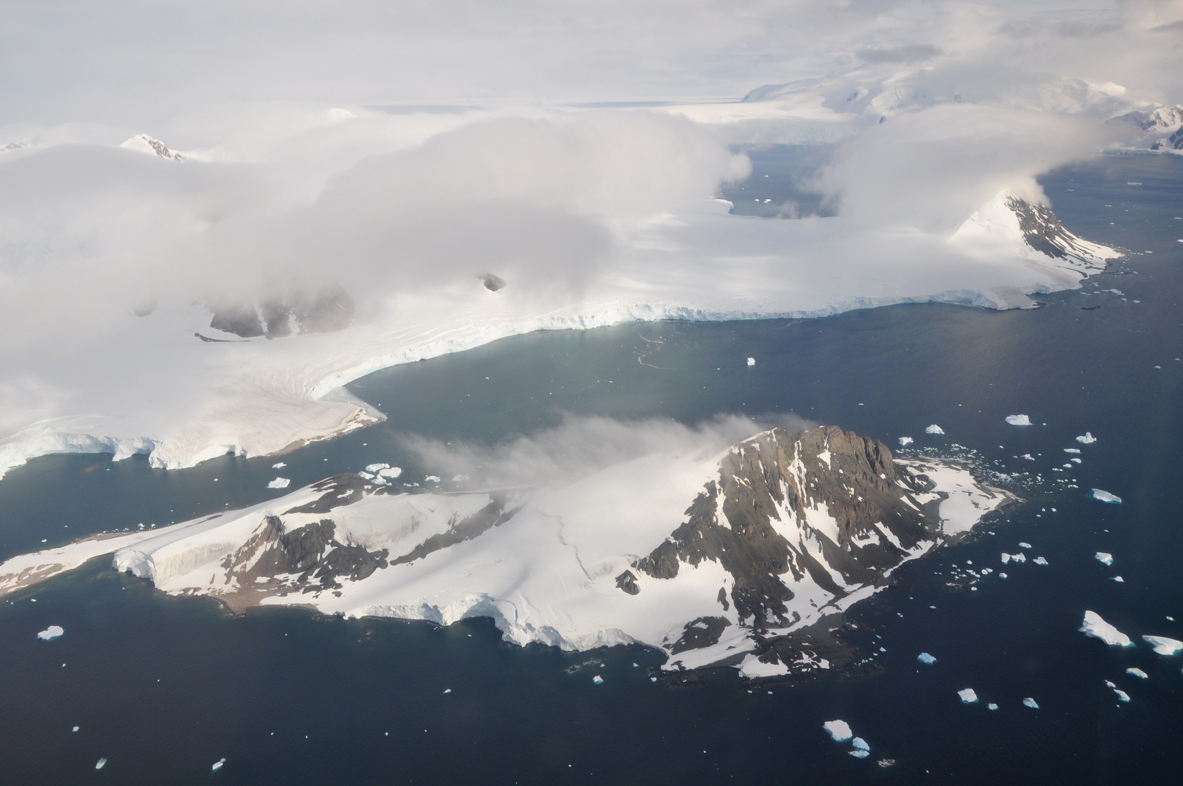
English: This picture is from the SW Antarctic Peninsula region. It's an aerial view from a position over Laubeuf Fjord, looking to the NW. In the foreground is Webb Island with its summit of 398 m. Behind it is a part of the Wright Peninsula on Adelaide Island's east coast. This coast's high ice cliffs are from the Wormald Ice Piedmont that covers most of the Wright Peninsula's east coast. The cloud-covered mountains on the left are the Stokes Peaks. The lone cloud-covered mountain at the right -at the NE extremity of the Wright Peninsula-is Sighing Peak; behind it is Stonehouse Bay. The maritime channel right of Sighing Peak is called Cole Channel (and is actually a part of Laubeuf Fjord). In the upper right hand corner of the picture is the Mount Bouvier Massif. At the foot of these mountains the Shambles Glacier can just be seen through a hole in the clouds. It is Adelaide Island's largest glacier and is heavily crevassed. |
| Data | |
| Fonte | Opera propria |
| Autore | Vincent van Zeijst |
•
| Luogo dello scatto | | Posizione di questa e altre immagini su: OpenStreetMap |
|---|
,_Adelaide_Island,_Webb_Island.JPG¶ms=-67.465978_N_-067.884522_E_globe:Earth_type:camera_heading:315.00&language=it)
Licenza
Io, detentore del copyright su quest'opera, dichiaro di pubblicarla con la seguente licenza:
Questo file è disponibile in base alla licenza Creative Commons Attribuzione-Condividi allo stesso modo 3.0 Unported
- Tu sei libero:
- di condividere – di copiare, distribuire e trasmettere quest'opera
- di modificare – di adattare l'opera
- Alle seguenti condizioni:
- attribuzione – Devi fornire i crediti appropriati, un collegamento alla licenza e indicare se sono state apportate modifiche. Puoi farlo in qualsiasi modo ragionevole, ma non in alcun modo che suggerisca che il licenziante approvi te o il tuo uso.
- condividi allo stesso modo – Se remixi, trasformi o sviluppi il materiale, devi distribuire i tuoi contributi in base alla stessa licenza o compatibile all'originale.
Cronologia del file
Fare clic su un gruppo data/ora per vedere il file come si presentava nel momento indicato.
| Data/Ora | Miniatura | Dimensioni | Utente | Commento | |
|---|---|---|---|---|---|
| attuale | 15:01, 12 mar 2011 | | 1 716 × 1 140 (404 KB) | Loranchet | {{Information |Description ={{en|1=This picture is from the SW Antarctic Peninsula region. It's an aerial view from a position over Laubeuf Fjord, looking to the NW. In the foreground is Webb Island with its summit of 398 m. Behind it is a part |
Utilizzo del file
La seguente pagina usa questo file:
Utilizzo globale del file
Anche i seguenti wiki usano questo file:
- Usato nelle seguenti pagine di azb.wikipedia.org:
- Usato nelle seguenti pagine di bn.wikipedia.org:
- Usato nelle seguenti pagine di bn.wikibooks.org:
- Usato nelle seguenti pagine di de.wikipedia.org:
- Usato nelle seguenti pagine di en.wikipedia.org:
- Usato nelle seguenti pagine di la.wikipedia.org:
- Usato nelle seguenti pagine di mk.wikipedia.org:
- Usato nelle seguenti pagine di ms.wikipedia.org:
- Usato nelle seguenti pagine di nn.wikipedia.org:
- Usato nelle seguenti pagine di no.wikipedia.org:
- Usato nelle seguenti pagine di sr.wikipedia.org:
- Usato nelle seguenti pagine di vi.wikipedia.org:
- Usato nelle seguenti pagine di zh.wikipedia.org:
,_Adelaide_Island,_Webb_Island.JPG)