File:1768 James Craig Map of New Town, Edinburgh, Scotland (First Plan of New Town) - Geographicus - Edinburgh-craig-1768.jpg
File originale(5 000 × 3 508 pixel, dimensione del file: 6,08 MB, tipo MIME: image/jpeg)

Logo di Commons
Logo di Commons
Questo file e la sua pagina di descrizione (discussione · modifica) si trovano su Wikimedia Commons (?)
Plan of the New Streets and Squares intended for the city of Edinburgh.
Artista
Titolo
Plan of the New Streets and Squares intended for the city of Edinburgh.
Descrizione
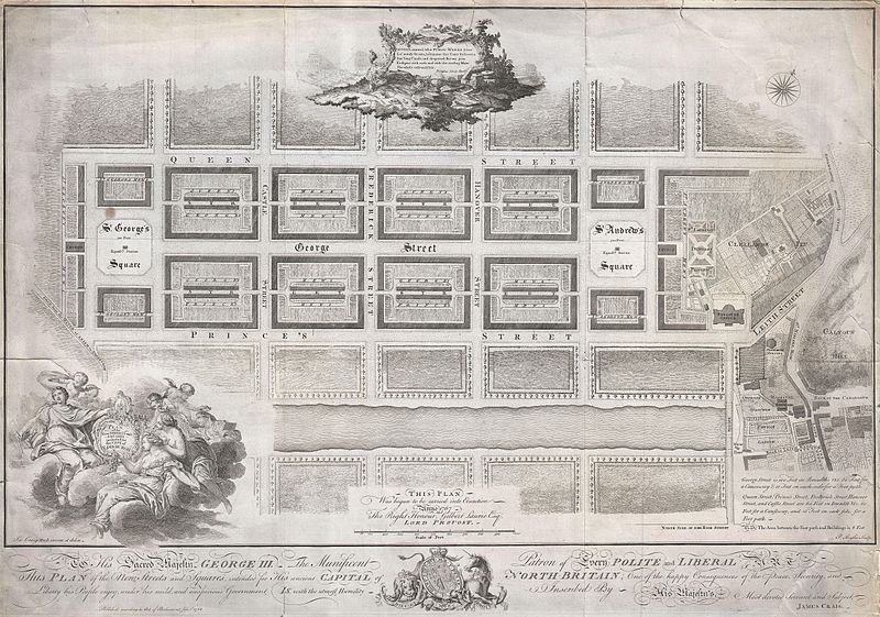
English: Drafted for the city planning committee in 1768 by James Craig, this is the definitive plan of Edinburgh, Scotland’s New Town. Oriented to the North, this plan details the streets of Edinburgh north of the Loch Nor (today the Prince’s Street Gardens) between St. George’s Square (modern day Charlotte Square) and St. Andrews Square. A dedication to King George the III illustrates the lower part of the map. An elaborate title cartouche decorates the lower left hand quadrant. Thompson’s poem appears in a secondary cartouche at the top center. In 1766 the City Fathers of Edinburgh lead by Lord Provost George Drummond instituted a plan to extend the city’s border to encompass the field’s north of the Nor Loch. The plan, intended to modernize the city and ease the crowded conditions of the old Royal Burgh, was turned into a competition. James Craig, an Edinburgh native, having around this time just completed his apprenticeship as a mason, found the he had a fine hand for drafting. Inspired by his uncle James Thomson’s well known poem Liberty , August, around, what Public Works I see, Lo’ stately Streets, lo’ Squares that Court the breeze, See’ long Canals, and deepened Rivers join Eash part with each, and with the circling Main The whole enlivened Isle… Craig submitted this plan. Though conservative in its vision, Craig’s plan won the city’s design contest and he was awarded with the “Freedom of the City” in 1767. Sadly the Lord Provost George Drummond who instituted the contest died before his dream of expanding the city was realized. It was left to his successor, the Lord Provost Gilbert Laurie, who is named on this map, to realize Craig’s plan. Today the streets are laid out much as Craig envisioned them with broad east –west avenues separating housing blocks bisected by smaller mews. Drawn by James Craig and engraved by P. Begbie in 1768. When this plan was printed in 1768, only 500 were issued. With such a small printing run as an independently issued map, we can safely assume that very few examples, other than the one you see here, have survived to this day. Only one recorded example of this map has appeared at auction in the last 30 years. Dated and copyrighted “Published according to Act of Parliament, Jan. 1st, 1768.
Data 1768 (dated)
Dimensioni altezza: 18 pollici (45,7 cm); larghezza: 26 pollici (66 cm)
dimensions QS:P2048,18U218593
dimensions QS:P2049,26U218593
Numero d'inventario
Geographicus link: Edinburgh-craig-1768
Fonte/Fotografo
Licenza
(Riusare questo file)
Questa è una fedele riproduzione fotografica di un'opera d'arte bidimensionale originale. L'opera d'arte fotografata è nel pubblico dominio per la seguente ragione:
Public domain

Quest'opera è nel pubblico dominio anche in tutti i Paesi e nelle aree in cui la durata del copyright è la vita dell'autore più 100 anni o meno.


Devi inserire anche un tag per il pubblico dominio relativo agli Stati Uniti per indicare perché quest'opera è nel pubblico dominio negli Stati Uniti.
La posizione ufficiale presa dalla Wikimedia Foundation è che le riproduzioni fedeli di opere d'arte bidimensionali nel pubblico dominio siano da considerare anch'esse nel pubblico dominio, e che qualsiasi affermazione contraria rappresenta un attacco al concetto stesso di pubblico dominio ("faithful reproductions of two-dimensional public domain works of art are public domain, and that claims to the contrary represent an assault on the very concept of a public domain"). Per maggiori dettagli, vedi Commons:When to use the PD-Art tag.
Questa riproduzione fotografica è di conseguenza da considerarsi nel pubblico dominio. Per favore, fai attenzione al fatto che, a seconda delle leggi locali, il riutilizzo di questo contenuto potrebbe essere proibito o limitato nella tua giurisdizione. Vedi Commons:Reuse of PD-Art photographs.

Didascalie

Aggiungi una brevissima spiegazione di ciò che questo file rappresenta

Elementi ritratti in questo file

raffigura

image/jpeg

d77403877c867d6b8f622485ff0d65fc8369261d

6 378 004 byte

3 508 pixel

5 000 pixel

Cronologia del file

Fare clic su un gruppo data/ora per vedere il file come si presentava nel momento indicato.

Data/OraMiniaturaDimensioniUtenteCommento
attuale23:16, 22 mar 2011Miniatura della versione delle 23:16, 22 mar 20115 000 × 3 508 (6,08 MB)BotMultichillT{{subst:User:Multichill/Geographicus |link=http://www.geographicus.com/P/AntiqueMap/Edinburgh-craig-1768 |product_name=1768 James Craig Map of New Town, Edinburgh, Scotland (First Plan of New Town) |map_title=Plan of the New Streets and Squares intended

La seguente pagina usa questo file:

Utilizzo globale del file

Anche i seguenti wiki usano questo file: